
TIDE is partnering with the University of Edinburgh, the Belize Forest Department, University of Belize Environmental Research Institute, and the International Institute for Environment and Development on a Darwin Initiative-funded project to conserve biodiversity and improve livelihoods in areas bordering the pine savanna woodlands in Toledo.
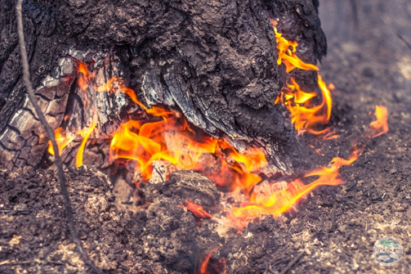
Pine woodland savannas in the Toledo district are fire-dependent ecosystems, but these ecosystems are often experiencing too much fire due to increasing numbers of escaped fires and wildfires as the climate becomes drier and warmer. Intense fires which occur later into the dry season are both reducing the biodiversity of these areas, for example by threatening the nesting sites of the endangered Yellow Headed Parrot that is endemic to these areas, but are also degrading the resource base such as the palmetto seed harvest which provides local communities with a valuable source of additional income in the dry season. Wildfire also poses a serious risk to people’s wooden houses, farms and health (heavy smoke load in in the dry season).
The project aims to engage local communities surrounding some of the pine woodlands and savannas in Toledo in stewardship that will help to conserve the biodiversity of these areas. This is being promoted firstly by providing training to members from the five communities of Bella Vista, Bladen, Medina Bank, San Isidro and Trio in safe use of agricultural fires, including training in carrying out prescribed burns during suitable weather conditions to reduce the risk of intense wildfire later in the dry season. The second part of the project aims to help these communities to develop viable small businesses that are based on a more sustainable use of the woodland resources and enhanced access to the protected areas of Bladen, Deep River and Paynes Creek National Park
Activities delivered by the project over the last year include:
Training for local communities in Prescribed Burns and Safe use of fire in Agriculture
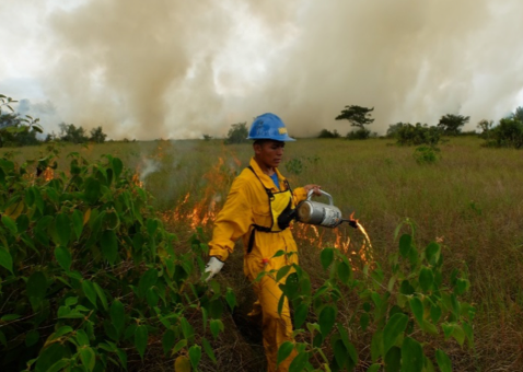
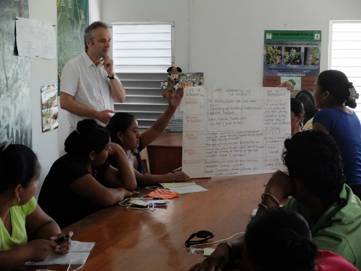
Community members take their developing skills in fire management from the classroom to the field |
Two days of fire training was given to 62 community members from the 5 target communities in February 2016. For each group there was a classroom session on the first day to explain fire use principles, and a practical session on the second day, in which participants led (with supervision from TIDE and a consultant from Everglades National Park), a prescribed burn in the Deep River Forest Reserve. The fire training will continue in year 2, as several of the villages clearly showed demand for more members to be trained. Additionally, we will deliver more advanced, week-long ‘train-the-trainer’ training to several of this year’s participants, enabling those people to become fire leaders in each of their communities.
Monitoring the effects of fires on the vegetation of the protected Areas
To monitor if the prescribed burning is helping to reduce further degradation and assisting with the recovery of biodiversity in the pine savanna, the project has established 12 permanent fire-effects monitoring plots across Paynes Creek National Park, in areas of varying pine density. These were set up with the help of 6 representatives from local communities in the area. A first round of data collection has taken place at these plots. All pine locations and diameters were mapped and measured and photo-monitoring points were established.
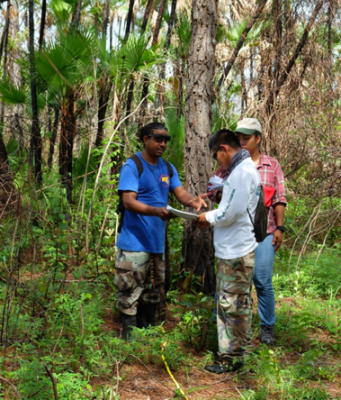
Data collection in a pine monitoring plot in PCNP
The plots were all revisited in August, following wildfires in some areas to take the next round of photos. All tree diameter data was also re-measured and verified on this return visit, and GPS locations of all the trees were taken to allow them to be mapped in GIS.
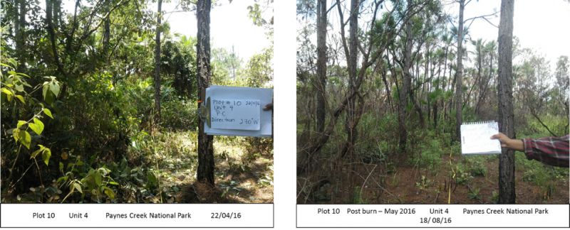
Photos taken at each plot allow the effects of different fire events to be assessed in woodlands with different vegetation structures.
Measuring Palmetto Productivity and abundance
Palmetto locations, and inflorescence were collected within the 12 plots in PCNP. An additional 16 plots for monitoring palmetto were set up in Deep River Forest Reserve (DRFR) and SBFR (Swasey-Bladen Forest Reserve) in May 2016. These plots were all revisited in August to estimate and record seed production, and the boundaries of the palmetto clumps were positioned using GPS for subsequent mapping in GIS.
Establishing a baseline understanding of wildfire frequency
An analysis of wildfire frequency was completed as a master’s dissertation at UoE using information about burning derived from the LANDSAT satellite data archive. Maps were produced showing inter-annual fire frequency between 2006 and 2016, and the year in which each area last burnt.
The analysis showed a greater proportion of the savanna component of SBFR burning annually (average 42%) compared to savannas in PCNP or DRFR (average 31%, 32% respectively). This helps to confirm anecdotal evidence that the areas receiving active fire management have less extensive and less frequent wildfires and establishes a baseline against which changes in fire extent and frequency may be assessed in future. You can see more of the results of the fire mapping at http://www.geos.ed.ac.uk/~mscgis/15-16/s0568630/
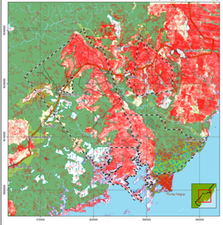
Inter-annual frequency of fire in Toledo District (2006-2015) Intensity of red colour increases with fire frequency
Working to secure the palmetto harvest:
A survey of 77 local palmetto harvesters was conducted in August. The aims of the survey were to better understand the logistics and locations of harvesting and sale, and community perceptions of the resource, in order to determine how best to protect the harvest against the effects of wildfire by appropriate timing of prescribed burning and how to support the palmetto harvesters through the project’s associated livelihood development activities.
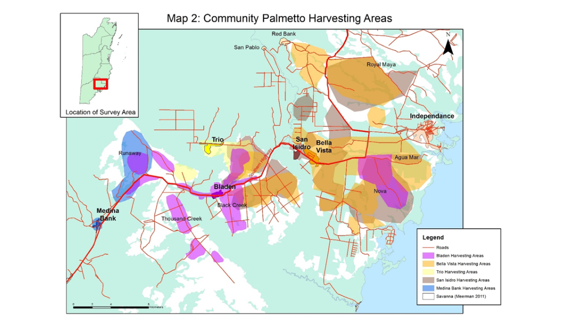
Map of areas used by each of the five communities to harvest palmetto
Developing business plans with community groups
5 community members and two project staff took part in a regional exchange from 11th-15th April 2016 between representatives from locally- controlled forest businesses from across Central America. The exchange was hosted by a federation of cooperatives, FEDECOVERA in Coban, Guatemala. The participants were able to visit a variety of successful community- run businesses, and hear the experiences of other small businesses in organisation, marketing, finance and political representation. Following the exchange, the participants presented their experiences in each of their communities. They were then given the opportunity to develop business ideas of their own within each community.
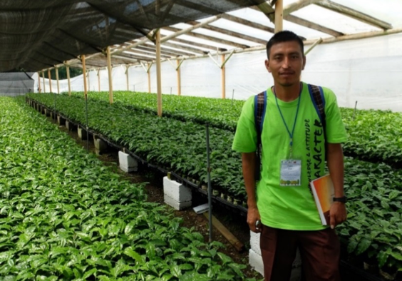
Visiting a coffee cooperative in Guatemala |
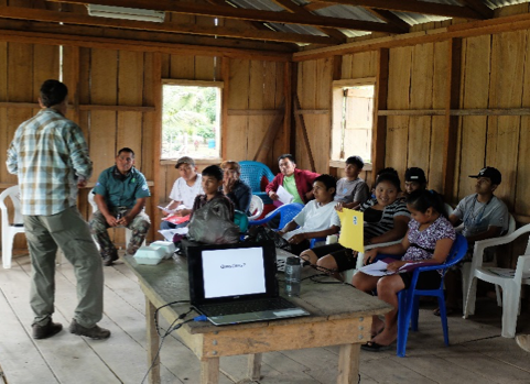
IIED led a 3-day introduction to group business for 6 community groups in August 2016. The training covered the benefits of group business, structure of a business, marketing a product and an introduction to accounting. The groups had to apply concepts to their own business ideas, and a series of activities left them with the notes that will form the first elements of a business plan.
Read more about the business training at http://www.iied.org/community-forest-farm-business-training-under-way-belize
Women from the proposed Kekchi Cuisine Restaurant recognise what additional information they will need to obtain before they can formulate their business plan.
NEXT STEPS
This Darwin project will continue until March 2018. Over this period the project partners will continue to actively build the capacity of the local communities, through enhancing their skills both in fire management and in business development, so that they are more able to actively conserve their local pine woodland resources and more able to gain benefits from the sustainable use of these woodland resources.
FIND OUT MORE ABOUT THE PROJECT
http://www.belizeconservation.site
http://www.darwininitiative.org.uk